DronaMaps leverages drone imagery to create large-scale 3D maps

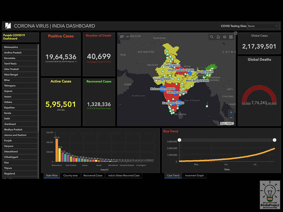
Founded by Utkarsh Singh and Ayushi Mishra, DronaMaps is a startup that leverages imagery collected through drones to create large-scale 3D maps. Both founders are Forbes 30 under 30 (Asia) alumni as well. The 3D maps are created with aerial photogrammetry where a consumer-grade camera is mounted on a drone and this camera captures multiple images at different angles. DronaMaps bolsters image reconstruction algorithms with strategic sorting of images and merging of small maps, all aided by deep learning algorithms developed in-house. DronaMaps' deep learning algorithms use the high-resolution maps captured by drones and identify 14 geospatial features required for development planning. Some of these geospatial features include the location of trees, plot boundaries, location of roads, utilities such as power lines, etc. The startup also stepped up during the Covid-19 pandemic and increased the types of data inputs their algorithm could accept to include the location of patients, quarantined individuals, hospitals, testing facilities, and others. They also helped develop a central Covid-19 tracking dashboard for India. The founders realised that their technology was capable of providing solutions for emergent needs from contact tracing to healthcare infrastructure management. At present, DronaMaps’ coronavirus solution has been implemented in Rajasthan, Haryana, Punjab, and a few others. DronaMaps was a part of Cohort 7 of the Nexus Incubator program. We spoke to co-founder, DronaMaps, Ayushi Mishra to learn more about the company and the technology.
DronaMaps: Using drone imagery to generate large-scale 3D maps
Digit: What is the process of creating 3D maps using drones? What are some of the applications of 3D mapping?
DronaMaps: 3D maps are created with aerial photogrammetry. The process requires a consumer grade camera mounted on the drone (usually with a gimbal for steadiness), this camera captures images at various angles, with point of interest, while the base map itself has the camera pointing vertically towards the ground (nadir). Photos taken by the camera have both overlap sideways and front overlaps of upward of 60% ( the balance here is resolution with computational capacity ). The reconstruction algorithms are tracking one point over multiple pictures and then assessing the Z axis value or the elevation. In itself, photogrammetry has gotten better but purely visual techniques do have high error on the elevation, so techniques like ground control points with DGPS or RTK equipped drones are also used for data collection. DGPS is cheaper and in line with the existing surveying industry, to complement them drones add larger coverage, smaller operational time, 3D visualization, and high accuracy.
There are several areas of challenges across this whole process, we do the drone image data procurement and ground control point DGPS assessments with existing partners in the industry who specialize in operations for both. As a differentiator, we have made the base algorithms like Poisson Surface reconstruction more efficient with our own pipeline that starts sorting through images removing irrelevant or highly exposed images in the very beginning, then creates chunks of images that form smaller pieces of the map. DronaMaps can create city scale 3D maps by merging several dense maps together and doing so without damaging the elevation accuracy of the overall map. At the end of all this are the deep learning algorithms for analytics. The deep learning algorithms are trained for detecting geospatial features, the same requirement serves across surveying, planning, and tracking industries. Another suite of our analytics serve precision agriculture and the mining industry. However, a majority of our clients are large enterprises or public organizations who need mapping and tracking of physical assets applied towards Smart Cities/ Villages, infrastructure planning and tracking.
Digit: During the COVID-19 pandemic, how is Drona Maps leveraging their drone 3D mapping technology to identify Covid hotspots?
DronaMaps: Our platform is designed to provide geospatial insights targeted towards decision makers. During the Covid 19 pandemic, we increased the type of data inputs it can accept to include location of patients (home base location, along with CDR, app, or VLR data), quarantined individuals, hospitals, testing facilities etc. Both cofounders Utkarsh Singh ( Computer Science) and Ayushi Mishra (MS) studied at Johns Hopkins University, which started the famous Covid tracking dashboard. We realised that not only did we have internal geospatial expertise to create tracking of this sort, we could actually provide a complete solution to state authorities which addressed everything from contact tracing to healthcare infrastructure management. One of the core challenges towards the same is how to localize the understanding of the pandemic such that it is actionable. For instance, disease transmission dynamics tracked by Ro and doubling time need to be assessed for each district, the land use and land cover patterns, demographic data, and population density at the ward level need to be understood for defining containment regions once a positive case is diagnosed in an area. Our expertise in analytics and geospatial intelligence was therefore applied towards creating a command and control center for 7 states in India, almost 130 districts.
Digit: How does the company source UAVs for the mapping process?
DronaMaps: DronaMaps specializes in reconstruction and analysis of images, operationally, we work with over 100 UAV partner companies who use their hardware to map areas requested by the clients. A portion of the per unit area revenue is allotted to data acquisition. On the end of drone partners, the equipment must be compatible with the latest guidelines from DGCA. In order to make our operations more scalable, we have automated algorithms for flight planning which reduce the variability in the data captured and also ones for fast assessment of the data captured to say for certain that the data quality is satisfactory while the operations team is still on the ground. These quality control procedures are devised to standardize our own operational pipeline.
Digit: How does Drona Maps’ technology help in getting started with precision agriculture? What are the benefits?
DronaMaps: Indian farms are often small ( less than 2 acres) with rampant intercropping, drones are a cost effective way to track the field with centimeter level resolution maps. The map making process is much the same as explained above, except, some drones have added sensors on top like multispectral or hyperspectral cameras to capture data from beyond the visual range. The differences for precision agriculture lie in the analytics suite, starting from elevation assessments of the layout of a farm and recommended crop distribution, and ending with periodic plant count and plant health reports to enable field management. Much like data from rural and urban development, agriculture data from India and other emerging countries present algorithmic and operational challenges. Most out of the box algorithms can’t differentiate between multiple crops in the field from weed and hence, the entire field is erroneously marked with weed stress.
In addition, we recognize that Indian agriculture is cost sensitive which means multispectral cameras might not be the solution for every farmer. Hence, we extended our capabilities within the visible spectrum to have indices that can detect new and mature leaves, along with plant classification, identification of biotic and abiotic stresses. The plant count and plant health analytics help in eventual yield estimation while we work with nonprofits who handhold the farmers on our recommended biological and chemical controls. This can potentially increase the yield of small farms by almost 30%.
Digit: Could you share some of the biggest takeaways from your association with the Nexus?
DronaMaps: Our first exposure to innovation and entrepreneurship was at our Alma mater— Johns Hopkins, which meant we were aware of the strategies that have worked in the international sphere. However, as we started the company in India with the spirit of contributing to the nation and using our technology to create the maximum impact on the human condition, it took us a while to adjust to the new context from a strategic perspective. Once we had done so successfully and were mature enough as a startup, Nexus helped us regain perspective by guiding us on the operational minutiae, introducing us to a VC network, lawyers to consult on intellectual property etc. It is a very hands on program that helps startups put a structure to their company with incisive insights from Eric Azulay, Vikas Sood, and Sameer Malik, all industry experts with years of experience of working in innovation.
Nexus Incubator is also now accepting applications for its 11th Virtual Cohort. Indian startups that are interested can check out this link.
Dhriti Datta
Perpetually sporting a death stare, this one can be seen tinkering around with her smartphone which she holds more dear than life itself and stuffing her face with copious amounts of bacon. View Full Profile


